Having decided to build a second Cariboo Wagon Road to replace the first one—which ran from Lillooet to Clinton and beyond via Pavilion—Governor James Douglas realized that he was proposing a new route that was, on the face of it, as arduous as the existing one. When, in October 1861, he commissioned the Columbia Detachment of the Royal Engineers to survey a route from Yale to Cook’s Ferry (the present-day Spences Bridge) through the Fraser and Thompson canyons, Douglas was already well aware of the route’s perilous nature and fearsome reputation.
In June 1860 a contract had been signed for the construction of a mule trail from Yale to Spuzzum, and in October of that year Douglas made the trip. He reported on the experience, describing “these frowning cliffs, which twelvemonth ago seemed to defy all efforts of improvement.” He continued, “The arduous part of this undertaking—excavating the mountain near Yale—was executed by a detachment of Royal Engineers under Sergeant Major George Cann, and it was completed in a manner highly creditable to themselves and to the officers who directed the operation.”
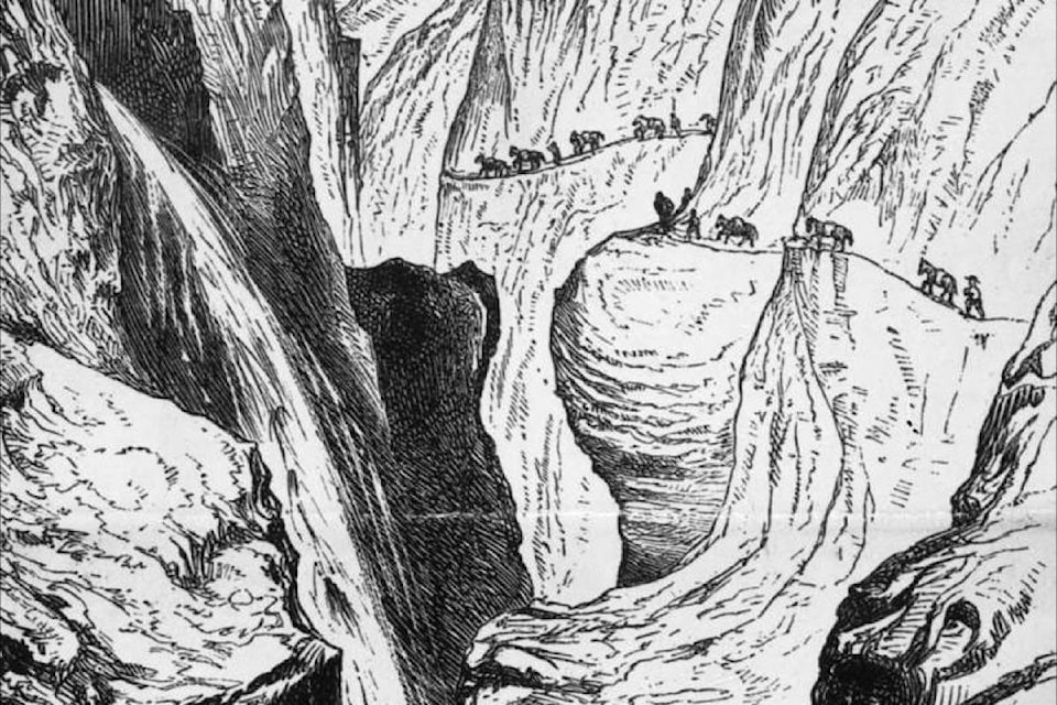
So when it came time to survey and build a new route through the same terrain, the Royal Engineers—or sappers, as they were colloquially known—knew precisely what they were up against. Lieutenant Richard Mayne of the Royal Engineers—after whom Mayne Island is named—had explored and mapped a good deal of the colony, and wrote of the route “The ground over which the trail passes is the roughest on which I have ever travelled, the greater part of it being over sharp-pointed rocks or granite boulders. Some of the ascents, in the Great Canyon which is six miles long, are from thirty degrees to sixty degrees and nearly perpendicular over the water.”
First Nations people had scaled the bluffs on intricate ladders made of vines and roots woven into ropes, or lashed logs together and floated them around the sheer rock faces. These solutions were not possible for a route meant to carry wagons and stagecoaches, so the sappers would have to find other methods.
Captain John Marshall Grant of the Royal Engineers was given the role of supervising the construction of the Cariboo Wagon Road immediately north from Yale, acknowledged as the most difficult part of the route. Overseeing men armed only with picks, shovels, and dynamite, Grant saw six miles of road, 18 feet wide, carved out of the rock walls above Yale during the first season of construction.
Trestles were constructed to carry the road around precipices, and in other places blasting powder was used to create space on which to construct a road, with sheer cliffs above and a steep drop below. Every existing ledge or flat bench was utilized, and where the route was forced to border the river it was sometimes necessary to build cribbing and fill it with stones.
Simply getting the men and equipment to the necessary places was an ordeal. Supplies were brought by boat to Yale, but there were hardly enough boats on the river as it was. Once the supplies for construction of the Cariboo Wagon Road were off-loaded at Yale, there was the problem of getting them northward. Many of the packers found it more lucrative to work the long-distance route to the Cariboo, rather than convey supplies a relatively short distance up the Fraser and Thompson Rivers.
Many European workers who had been brought in, and who in some cases were paid in advance for their work, deserted when they heard news of a fresh gold strike somewhere, without paying back their wages; others left when the promised financial support from Britain failed to materialize on time (or at all) and their wages were delayed. Chinese and First Nations workers were employed, with First Nations workers carrying loads on their backs, but smallpox devastated both communities.
Joseph Trutch, who had undertaken to build a 300-foot suspension bridge (the first such structure in the colony) across the Fraser north of Spuzzum, found it impossible to get steel cables transported to the site by mule, so hit on an ingenious solution. He had bales of wire packed in, with the wire wrapped together at the site. The makeshift cables—so well made that no single wire ever snapped—were stretched from anchors made of masonry on either bank across wooden towers in the river, with a wooden deck suspended from them. The work on the bridge was completed in just two-and-a-half months, and when the first load went over it—a four-horse team with a three-ton load—the deck level changed by a mere quarter-of-an-inch.
This was the first Alexandra Bridge, and it remained in use until the deck was washed away in the high water of 1894. At Cook’s Ferry another bridge was built across the Thompson; it was likewise destroyed in 1894.
That bridge was almost immediately replaced, but it would not be until 1926, and the advent of the province’s first modern highways, that Alexandra Bridge would be replaced.
By 1864, the Cariboo Wagon Road had been completed. Its course was in large part dictated by the natural features—rivers, mountains, valleys—it traversed, but it is a testament to the men who planned and built it that no better course has ever been found. The modern highway still largely follows the route laid out 150 years ago, allowing modern travellers to follow in the footprints of history.
In the last instalment, it was stated that the Royal Engineers’ base at Derby Reach (now part of Langley) was also called Sapperton, and a photograph of Sapperton was used. Sapperton was in fact a distinct community in what is now New Westminster.