Have you ever wondered about some of the names along the 121.5 mile stretch of railway between Kamloops and North Bend that is known as the Thompson Subdivision (Canadian Pacific) and the Ashcroft Subdivision (Canadian National)?
Some of the station names — such as Kamloops, Savona, Walhachin, Ashcroft, Spences Bridge, and Lytton — are obvious, as the communities they served still exist, and the meaning behind the name is not hard to find. Others, however — including Benledi, Nepa, Toketic, and Drynoch on the CP line, and Kissick, Jaleslie, Lasha, and Inkitsaph on CN — are not as obvious when it comes to finding out why they carry the names they do.
In 1947, the Ashcroft Journal noted that there were some 22 trains per day running along the CP line through this stretch of railway, with 10 of those trains being intercontinental passenger trains. There were stations large and small along the route, and these station names remain, even though in many cases the stations themselves are long gone.
Today the CP line through the Thompson Subdivision carries as many as three dozen trains (or more) per day, almost exclusively freight trains. These trains are considerably longer than their 1947 counterparts, which would probably have been in the range of 2,000 feet long; today, freight trains can reach lengths of up to 14,000 feet, or well over two miles.
This article (part two of two) looks at the station names on the CP line from Black Canyon near Ashcroft to North Bend, as well as one name from east of Kamloops in the Shuswap Subdivision, and one well-known name along Highway 1; part one examined the meanings behind the CP station names between Kamloops and Ashcroft. A future article will look at the CN station names in the same stretch, although there is considerable duplication between the names.
READ MORE: Where and what is Benledi? The stories behind CP station names
While the official term for the signs is station names, they do not necessarily mean there was an actual station there; they can also indicate the presence of such things as sidings, connections, or signals. The station name signs are parallel to the tracks; there are also mile board signs at a right angle to the tracks a mile out from the station name sign.
Also worth noting is that while the two railways operate their own lines, there is an agreement between them to have “directional running” along the Thompson and Fraser Rivers between Nepa (west of Ashcroft) and Mission-Matsqui in the Cascade Subdivision (CP)/Yale Subdivision (CN): with a few exceptions, all trains travelling east between these points use the CP tracks, while all trains travelling west use the CN line.
BLACK CANYON (Mile 52.8 from Kamloops): Black Canyon is a noted geologic feature west (south) of Ashcroft on the Thompson River, where steep cliffs of sedimentary rock crowd in upon the river, narrowing it considerably. The CPR Annotated Timetable from 1906 describes it thus: “Three miles beyond Ashcroft the hills press close upon the Thompson River, which cuts its way through a winding gorge of almost terrifying gloom and desolation.” On Oct. 14, 1880 a landslide at the site blocked the river and caused the water to back up behind the debris, flooding what would become the Ashcroft townsite. The floodwaters — which rose as high as 80 feet behind the dammed-up area — threatened Harper’s Mill at the mouth of the Bonaparte River east of Ashcroft; a sign beside the CN line at the site shows the height the water reached, while a sign at the Ashcroft Museum which used to be on the side of the mill building indicates the high water mark at the mill.
NEPA (Mile 54.8): The origin of this name — pronounced “Nee-pa” in English — is uncertain. However, in his 1900 book The Thompson Indians of British Columbia, ethnographer James Teit says that there was an Nlaka’pamux village or settlement called Snapa’ (meaning “burnt place”) at or near the site of where Nepa is today. The Canadiana site (www.canadiana.ca), which reproduces a report from 1899 that includes the names of Nlaka’pamux settlements in the region, calls the site C’npâ’, which means “barren or bare place”. The entire area to the west (south) of Black Canyon, where Nepa is located, has been prone to landslides for hundreds, if not thousands, of years, which could have given rise to the First Nations name.
BASQUE (Mile 56.8): The name is derived from settler Antoine Minaberriet (the name is now spelled Minnabarriet) and several companions, who came to the area from the Basque region of France in the early 1860s and established a roadhouse and ranch along the Cariboo Waggon Road near Venables Valley. Grain and hay were the main crops of the ranch, where Minaberriet also grew grapes, which he turned into wine that was served at his roadhouse.
TOKETIC (Mile 64.0): Toketic means “pretty” in Chinook Jargon (also called Chinook Wawa, Chinook, or Jargon), which was the trade language of the Pacific Northwest and spread during the 19th century from Oregon and Washington to British Columbia; it was in use as far south as California and as far north as Alaska. It is partly descended from the Chinook language; 15 per cent of its lexicon is French, and there are loan words from English and other languages. Some Chinook Jargon words still in use by English-speakers include cheechako (newcomer); mucky muck or muckamuck, which means “plenty of food” and came to mean someone who lives well; skookum, best known as an adjective meaning strong, big, or genuine; and tyee, which means leader or chief.
SPENCES BRIDGE (Mile 72.8): When the Cariboo Waggon Road was being built in 1862, Thomas Spence was given the contract to construct a bridge across the Thompson River at what was then called Cook’s Ferry, named after Mortimer Cook, who ran a cable ferry across the river there from 1862 to 1866. Part of Spence’s payment for his work came from being able to charge a toll on the bridge, and when it was completed the bridge put the ferry out of business (although it was used occasionally, such as during the flooding of 1894 which washed away the bridges at Savona, Ashcroft, and Spences Bridge on the Thompson, and the original Alexandra Bridge on the Fraser River near Spuzzum; it was also used following the Great Slide south of Spences Bridge in 1905). With the ferry more or less superseded by the bridge, the town became known as Spence’s, and then Spences, Bridge.
DRYNOCH (Mile 79.3): Jessie Smith and her husband John emigrated from Scotland to Spences Bridge in 1884, where they became orchardists and ranchers. In her memoir Widow Smith of Spences Bridge, Bessie talks about the construction of the CPR and the coming of the railway, writing that “Mr. H.A.F. McLeod was Mr. Onderdonk’s resident engineer at a construction camp a few miles west of Spences Bridge. Mr. McLeod had named his camp Drynoch, chosen for Drynoch, on the Isle of Skye, Scotland, which was the seat of the McLeod clan.” McLeod was the resident engineer for the Canadian government, and was in the area between 1882 and 1885.
THOMPSON (Mile 85.6): The site is named after the river, which was named (by Simon Fraser) after his friend and fellow explorer David Thompson when Fraser came through the region in 1808. Thompson was never in the area and thus never saw the river that bears his name. A popular and well-known roadhouse near the First Nations village called Nicomen flourished during the Gold Rush and then during the building of the Cariboo Waggon Road, but was bypassed by the road, and its popularity fell. With the arrival of the CPR, Nicomen became known as Thompson Siding. Nicomen is derived from the Nlaka’pamux word NEqa’umin or Nqau’min, which Teit said is “so named because the water comes from a lake called Nqauma’tko (‘wolf lake or water’) from sqaum (‘wolf’).” Today the river and its falls are spelled Nicoamen, while the settlement is Nicomen.
[Tank Hill: Not a station name, but a landmark along Highway 1 east of Lytton, Tank Hill was much in the news after the atmospheric river that swept through southern British Columbia on Nov. 14-15, 2021. The highway passed beneath the CP mainline at that point, but a massive washout left both transportation corridors in tatters at Tank Hill. CP service through the canyon was restored just over a week later, but Highway 1 between Hope and Spences Bridge did not reopen until Jan. 15, 2022, with a temporary at-grade highway crossing of the CP line at Tank Hill. The name comes from the early days of the CPR, when steam engines required water. CP built a large water tank or reservoir at the site, which was near its line. The tank was fed with water from a water tower above it, which got water from a nearby creek.]
[Gladwin (Mile 90.1): This station between Thompson and Lytton no longer has a connection or siding, and was eliminated as of Feb. 6, 2003. The name comes from Walter D. Gladwin, who appears to have operated a roadhouse at the site, although there is very little information about it. Gladwin was a resident of Yale when the Gold Rush started in 1858; in later years he moved to Ashcroft and became a freight forwarder on the Cariboo Waggon Road. The Thompson Canyon at Gladwin was known at the time as the “Jaws of Death”, and the name is still used by river rafters to refer to the Thompson River there.]
LYTTON (Mile 94.9): The town at the confluence of the Fraser and Thompson Rivers has been the centre of the Nlaka’pamux Nation for thousands of years. It was known by white settlers as “The Forks” or variations on Kumsheen, a transliteration of the Nlaka’pamux name for the site that has several meanings, including “where the rivers meet”. In 1858, when the colony of British Columbia was established at the start of the gold rush, the site was identified as a key one along the gold rush route, and in late 1858 it was given the new, official name of Lytton after Sir Edward Bulwer-Lytton, who was Secretary of State for the Colonies. He was also a best-selling novelist who has gained infamy for the opening line “It was a dark and stormy night” from his 1830 novel Paul Clifford.
CISCO (Mile 100.3): According to Teit in The Thompson Indians of British Columbia, there was an Nlaka’pamux settlement eight miles south of Lytton called “Si’ska”, meaning “uncle”, which he noted that the whites called Cisco. The word siska has also been defined as meaning “unpredictable”, a reference to the flow of water from a nearby creek.
KANAKA (Mile 104.6): Kanaka is a Hawaiian word meaning “human being”. A large number of Hawaiian Islanders came to the area for the gold rush in 1858 and mined for gold at the site, now called Kanaka Bar, white settlers having taken the word “kanaka” and applied it to anyone from Hawaii (in particular) or Polynesia at large.
KEEFERS (Mile 110.8): Keefers (sometimes called Keefer’s) was named after George Alexander Keefer, a surveyor and construction engineer who had worked for the Canadian Pacific Railway in eastern Canada. Keefer was in charge of building the CPR line between Boston Bar and Lytton. An 1885 photograph titled “The Chinese community at Keefers” was taken by Charles Macmunn, a British-born, Victoria-based photographer who specialized in views of the railway. Keefer’s house was near the railway yard across from the camp.
CHAUMOX (Mile 116.5): The origin of this name is uncertain. James Teit noted that east of what we call North Bend and west of Keefers there was a village called Tsa’umåk (he gives no meaning for the word), which could be the origin of the name Chaumox. The 1899 list on the Canadiana site places a settlement called Tzau’ämuk at the same spot Teit does; the name is said to mean “noise of rolling stones in bed of stream”. It could also be from Chinook Jargon, although no equivalent word has yet been found. There is a Chaumox Road in North Bend, and the landfill operated by the Fraser Valley Regional District there is called Chaumox; there was also a school at Chaumox through at least the 1920s. A School District Information Report from March 1923, completed by Gladys M. Thompson (presumably the teacher at Chaumox school), noted that there were nine children enrolled, with an average daily attendance of six students. “There is only one white family in the district, with whom the teacher must board,” Thompson wrote in the report. “The Indian rancheree [reserve] is about a mile distant. No social life whatever.”
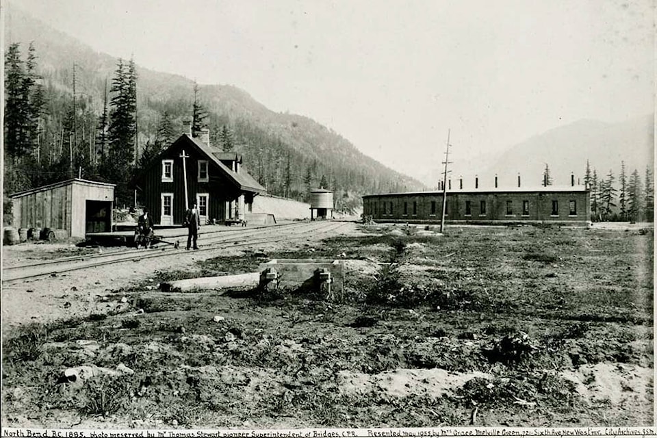
NORTH BEND (Mile 121.5): Teit says that the Nlaka’pamux called North Bend Kapateî’tein or “sandy shore”. Presumably the English name comes from the bend in the Fraser River at this point. North Bend marks the western end of CP’s Thompson Subdivision; CN’s equivalent subdivision, Ashcroft, extends as far west as Boston Bar.
CHENG (Shuswap Subdivision): Just east of the CP yard in Kamloops at the western end of the Shuswap Subdivision is the station name Cheng, which was named on May 27, 2005. It marks a connection point between the CP and CN lines, and was named for Cheng Gin Butt, who was born in Southern China’s Guangdon province in 1858 and emigrated to Canada; he eventually settled in Yale. The Cheng Interchange is marked in English and in simplified Chinese, and is the only bilingual sign on CP’s entire network. It honours the thousands of Chinese labourers who, like Cheng, worked to build the western section of the CPR from Port Moody to Craigellachie.
Sources
Akrigg, G.P.V & Akrigg, Helen. British Columbia Place Names. Sono Nis Press, 1986.
Balf, Mary. Why That Name? Place Names of Kamloops District. Kamloops Museum, 1978.
Fandrich, Bernie. British Columbia’s Majestic Thompson River. Nicomen House Publishing, 2013.
Lyons, C.P. (original author). Historic Fraser & Thompson River Canyons. Heritage House, 1986.
Patenaude, Branwen C. Trails to Gold. Horsdal & Schubert, 1995.
Patenaude, Branwen C. Golden Nuggets: Roadhouse Portarits Along the Cariboo’s Gold-Rush Trail. Heritage House, 1995.
Smith, Jessie Ann, as told to J. Meryl Campbell & Audrey Ward. Widow Smith of Spences Bridge. Sonotek Publishing, 1989.
Teit, James. The Thompson Indians of British Columbia. American Museum of Natural History, 1900.
editorial@accjournal.ca
Like us on Facebook and follow us on Twitter