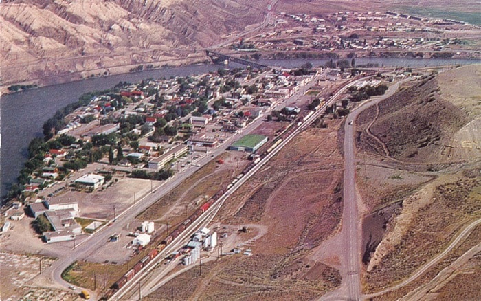
I have, sitting before me as I type, a picture postcard of Ashcroft which I recently purchased on eBay for the magnificent sum of US$2.25 including postage. It’s an aerial shot, in colour, with the photographer (whose name, Jim Reichert, is printed on the back of the card) hovering immediately above the junction of Hwy 97C and Mesa Vista Drive, looking northwest. It’s clearly not a recent photograph, as even a cursory glance at it shows; but when exactly was it taken?
There’s no date printed on the back, and no handwritten date either; the postcard was never sent, so there isn’t even a post office cancellation mark to help. Undated photographs are one of the banes of a historian’s - even an amateur one such myself - existence. (And please don’t get me started on undated letters. Arthur Conan Doyle left a voluminous correspondence behind, much of it preserved in collections, but he seldom dated any of his letters, leaving researchers dependent on internal evidence to try to figure out in what decade, let alone year, a given letter was written).
Internal evidence can be very helpful, however, whether dealing with photographs or letters. For example, what is, or is not, in a photograph can help to pin down a date; so to try to determine when the picture was taken, I scanned it, blew it up, and began investigating.
The first thing that I looked for was the Ashcroft Hotel, at the corner of 4th and Railway where the Post Office now stands, and which burned down in 1974. There the hotel is, across the street from a patch of grass where the parking lot for the Lady Minto Plaza now sits. So the picture was clearly taken before 1974.
Could I determine a year after which the picture must have been taken? A glance at the corner of 7th and Railway shows that the cannery buildings which once occupied the spot are gone, and the Sage and Sands Hotel sits there instead (at the spot where the MCFD building now is). The cannery closed in 1957, so already we’ve narrowed the dates down to sometime from 1958 to 1974.
Could I narrow that 16 year window even further? As a resident of the Mesa, my eye was drawn to that area of the photo at lower right. There’s a road going up to the Mesa from 97C, but the townhomes that now sit between highway and road aren’t there, and there’s no evidence of any houses where Cliff Crescent or Vista Place now run. This would seem to indicate that the picture was taken before 1970 or thereabouts, when building began on the Mesa, so we’ve chopped four years off the time span.
(As a side note, there appears to be a cleared, fairly wide space to the right of what’s now Mesa Vista Dr., paralleling that road. My initial thought was that this space became Mesa Vista Dr., replacing the original road, but a look at Google Earth shows that traces of this cleared area beside Mesa Vista still remain, much overgrown but quite distinct. Was there a plan, at one time, to build the road up to the Mesa in a different spot; a plan that was later abandoned?)
What next? Well, the Sage and Sands Hotel was built around 1959–60, so that’s lopped a couple of years from that end of the time frame. The highway layout at the far end of town, coming off the bridge and connecting with 97C, looks as it does today, and work on that was started in the summer of 1964. Looking across to the far side of the river at the top right of the picture, we can see the Hill Street apartments and townhomes, with a small building beside them towards the bottom of Hill. That’s the original Ashcroft Elementary school, constructed in 1950; the addition that turned the building into the one we know today was completed in 1967, but it’s not there.
So we’ve narrowed it down to the picture being taken after 1964 (when changes were made to 97C at the north end of town) and before 1967, when Ashcroft Elementary was enlarged. I’m going to pick a year, and say 1965.
What are a few notable changes in the intervening 50 years? Well, Coppervale Elementary School is there at bottom left, where Villa Fronterra now stands, with the Lady Byng School (built in 1921 at a cost of $16,000) across from it on the same site. The curling rink is at 7th and Bancroft, but there’s no arena beside it, just an empty lot (the original arena was built in 1975, and burned down the following year). Where the parking lot on the river side of the current arena is now located are four modular homes or trailers; the School District still owns land there, and years ago the District had trailers on the site, which were used to accommodate teachers.
The old fire hall, now at the north end of Railway, is still on Railway itself, beside the site of the current fire station, and J.J. Ting’s store - formerly Foster’s General Store, built in 1886, and the oldest surviving building on Railway - can be seen where the empty lot between Nature’s Gifts and Jackie Tegart’s office is now (the entire block, including Ting’s, was destroyed by fire in 1977). On the far side of the bridge, and to its right, can be seen the old Ashcroft pool, which went to make way for the current bridge in 1991.
So I’ve managed to date my mystery photo, and take a little trip back in time as I did so. However, there’s one mystery remaining about this picture, and I direct you to this week’s “Letters” section on page 5, if you’d like to help me play detective and solve it!
Barbara Roden