When it was built in 1862, the Cariboo Wagon Road north from Yale to Ashcroft and on to the goldfields of the north was considered an engineering marvel, overcoming as it did the challenges presented by the Fraser and Thompson River canyons. However, the current route—the Trans-Canada Highway—through that same area is almost as much of a marvel, given the inhospitable landscape and lack of options as to where a road could go.
This column often looks back at a time that no one now living can remember. However, history isn’t necessarily that far distant from us, and I’m sure that many readers will recall what it was like to drive from Vancouver to Ashcroft and points beyond—both east and north—before the Trans-Canada Highway (TCH) was built.
We now think of cars as just about the only way of getting to and from the Interior; but after the Cariboo Wagon Road fell into disrepair beginning in the 1880s, the Canadian Pacific Railway was the main means by which people got to the area. It was joined by the Canadian Northern Pacific Railway in 1915, which was later nationalised as part of Canadian National Rail.
It wasn’t until the 1920s that the roads to the Interior were restored and improved. The provincial government was responding to the clamour of those newfangled creatures, motorists. Cars, which had once been prohibitively expensive for all but the wealthy, had become affordable for almost everyone, thanks to Henry Ford and his production line assembly techniques.
By the 1920s the number of people who owned cars had skyrocketed; and not unnaturally, they wanted more roads on which to drive them, and ways of getting to otherwise inaccessible parts of the province. In 1920 surveying started on a new road, and construction began in 1924.
Since the CN and CP railways had already taken advantage of the most advantageous routes through the Fraser and Thompson canyons, finding a suitable route for the road was a difficult task. At some points it was able to follow the old Wagon Road, but in others it had to forge a new path. A new Alexandra Bridge was put in place, to replace the one that was washed out in 1894. It was in turn replaced by the current bridge during the building of the TCH, and is closed to traffic, but can still be accessed by a trail and crossed on foot.
Those who are inclined to curse the modern highway through the Fraser and Thompson canyons should count their blessings. The current China Bar tunnel replaced a section of the 1926 highway that terrified travellers—especially in wintertime—because it clung to the cliffs on one side, and had a sheer drop of several hundred metres into the river on the other. At 2,000 feet, China Bar is the second-longest car tunnel in North America, and the one mile section of highway which includes it cost $5 million to build; the most expensive section of two-lane highway ever built in B.C. at that time.
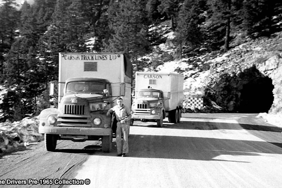
Some sections of the road were single lane in one direction only before the TCH, meaning that if a motorist met someone coming in the opposite direction, one of them had to back up to where the road was wide enough to let the other pass. A family travelling from Vancouver to the Shuswap, before the modern highway was built, could count on a two-day journey; many people doubtless broke the trip with an overnight stay at the Bighorn Auto Court south of Spences Bridge, with its cabins and an in-ground pool.
In the 1950s the road was overhauled as part of the TCH, which was approved in 1949; work began on the Highway in 1950. The seven tunnels travellers now encounter on their way to the Interior were constructed between 1957 and 1964. From south to north they are Yale (completed in 1963), Saddle Rock (1958), Sailor Bar (1959), Alexandra (1964), Hell’s Gate (1960), Ferrabee (1964), and China Bar (1961). Travellers curious to know what tunnel construction looked like in earlier days (one word: basic) can walk to the original Hell’s Gate tunnel, to the west of the current tunnel (park in the old Elvis Rocks the Canyon parking lot and follow the trail to the old tunnel, which can still be traversed, although stout walking shoes and a flashlight are recommended).
While tunnels were an option through the Fraser Canyon portion of the highway, they weren’t along the Thompson River, where a train line on one side and the river on the other left almost nowhere to go. The solution was to build into the river channel itself, with the highway supported on steel retaining walls filled with gravel. These sections are clearly visible to river rafters, but highway travellers can also see some of them from the road.
The auto court at Bighorn was far from being the only one along the route. Auto courts had started up in the 1920s, as a way of catering to motoring traffic. Less expensive than hotels, they typically offered cabins that could be rented by travellers, and the sites often had shops that sold an assortment of food and dry goods, as well as offering pools, showers, and bathrooms. The T.U. Auto Court in Cache Creek—located where the post office now stands—was a local landmark for many years, and Ashcroft had its own auto court, above where the River Inn stands.
By the time the Trans-Canada Highway was built in the 1950s and 1960s, however, auto courts were on the way out, supplanted by motels (the word motel was made by combining the words “motoring” and “hotel”). With inexpensive motels all along the highway, and drivers able to cover longer distances at a time, the days of the auto court were numbered. The Ashcroft auto court was gone by 1964, when changes and improvements to what is now Highway 97C widened the road and relegated the auto court to the pages of history.
editorial@accjournal.ca
Like us on Facebook and follow us on Twitter