A very cold February with high precipitation throughout much of the province has led to an above average snow pack (119 per cent of normal) across British Columbia. Very high snow packs (>135 per cent) in the South Interior (including the Skagit, Similkameen, Okanagan, Boundary, and Upper Fraser West), and high snow packs (>120 per cent) in the Kootenay, indicate an increased seasonal risk of flooding.
This information comes from the BC River Centre Forecast on March 8, which notes that in February, precipitation was well above normal for most locations in the Interior (Kamloops reported the most February precipitation in 80 years). In the South Thompson, the snowpack is at 110 per cent of normal, and one local group has started preparing now for what could be another bad flood season in the area.
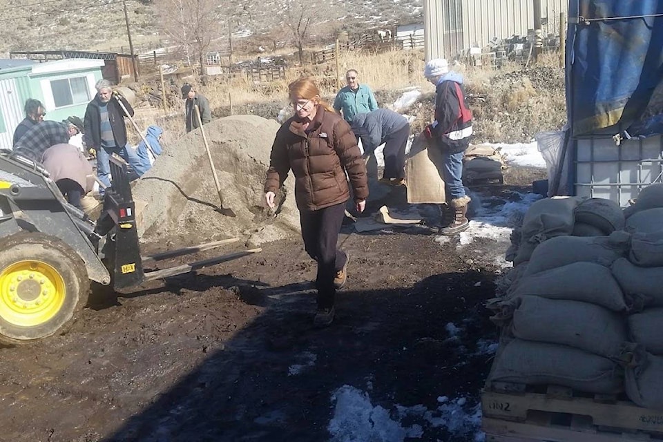
On March 10, community members of 16 Mile met for a sandbagging bee, filling bags and getting them in place on the community lot on Hills Frontage Road so they are ready to go if needed. “This community was spared most of the ravages of last summer’s wildfire as a result of the cooperative efforts of the wildfire professionals and those who stayed behind using the community society resources (well storage, hydro, and back-up power) on the night of July 14,” says Al Midgley.
He notes that while the community assets were almost all still there the next morning, land to the east and west was severely burned. “With the amount of burned country above us and around us, the community decided to take precautions and be prepared for debris flow from these burned hillsides. This debris tends to plug watercourses and cause flooding in unnatural places, thus the need for protection as best we can with sandbags.
“We had small flows that caused damage last fall when we had a rain. Now we have a large snow pack that will melt and come through our ravines and river.”
While Midgley acknowledges that they hope not to have to use the bags, they are ready to go if the need arises. “We’ve taken the precaution, and no time has to be spent in an emergency acquiring the response materials.
“This is a continuing effort of all community stakeholders to be fire and flood smart, of trying to learn how to protect our community more, and of neighbours helping neighbours.”
La Niña conditions in the equatorial Pacific Ocean have eased over the past month, but it is not uncommon for the effects of La Niña to persist for several months beyond the period of the defined La Niña event. Snow packs in previous La Niña events in British Columbia tended to grow more rapidly than normal through the March and April periods, and while there is still uncertainty over how weather patterns will play out over the next few months, continued increases in snow basin indices into April and May are likely to occur.
Nearly 80 per cent of the annual B.C. snow pack typically accumulates by early March. Given this year’s La Niña conditions, it is unlikely that the risk will ease much prior to the melt season.
While the snow pack in the overall Fraser River basin is moderately above normal (110 per cent), a high snow pack (122 per cent) in the Lower Fraser can contribute to increased spring flood risk on the Lillooet River and tributaries. Increased seasonal runoff in the spring can also contribute higher local inflows to the lower reaches of the Fraser River. Given the potential for increasing snow packs over the next four to eight weeks, there is the possibility of increasing seasonal flood risk in other areas of the province.
Seasonal volume runoff forecasts are near-normal (95 to 110 per cent) for the Upper Fraser, Middle Fraser, Thompson, and Skeena/Bulkley basins, and well above-normal (>130 per cent) for areas of the South Interior, including the Okanagan, Similkameen, and Nicola.
Similarly, the snowmelt component of seasonal runoff on Vancouver Island, South Coast, Lower Fraser, and Skagit is expected to be higher than normal given the high snow pack in those regions.
Snow pack is one element of seasonal flood risk during B.C.’s freshet season. Weather patterns during the snow melt season play a critical role in whether or not flooding occurs. Intense or prolonged rainfall and extreme temperatures are important factors that can lead to flooding, even for areas with a near normal snow pack.
Full details on the snow bulletin, including the snow basin index map and snow survey data, can be found at http://bit.ly/2Fy3O9a.
editorial@accjournal.ca
Like us on Facebook and follow us on Twitter