The BC River Forecast Centre is warning that this spring’s flood risk has increased considerably due to colder than usual April temperatures across the province and a delayed snowmelt. The continued cool weather so far in May is increasing the risk for major flooding if a prolonged heat wave occurs later this month or in June.
Across B.C., the May 1 snow pack is above normal. The average of all snow levels in the province has increased to 113 per cent of normal over the past month (on April 1 the average stood at 99 per cent), largely because the cooler temperatures have delayed snow melt. This combination of an above normal snow pack, colder April and early May temperatures, a delayed melt, and additional precipitation have significantly increased the risk of flooding this spring.
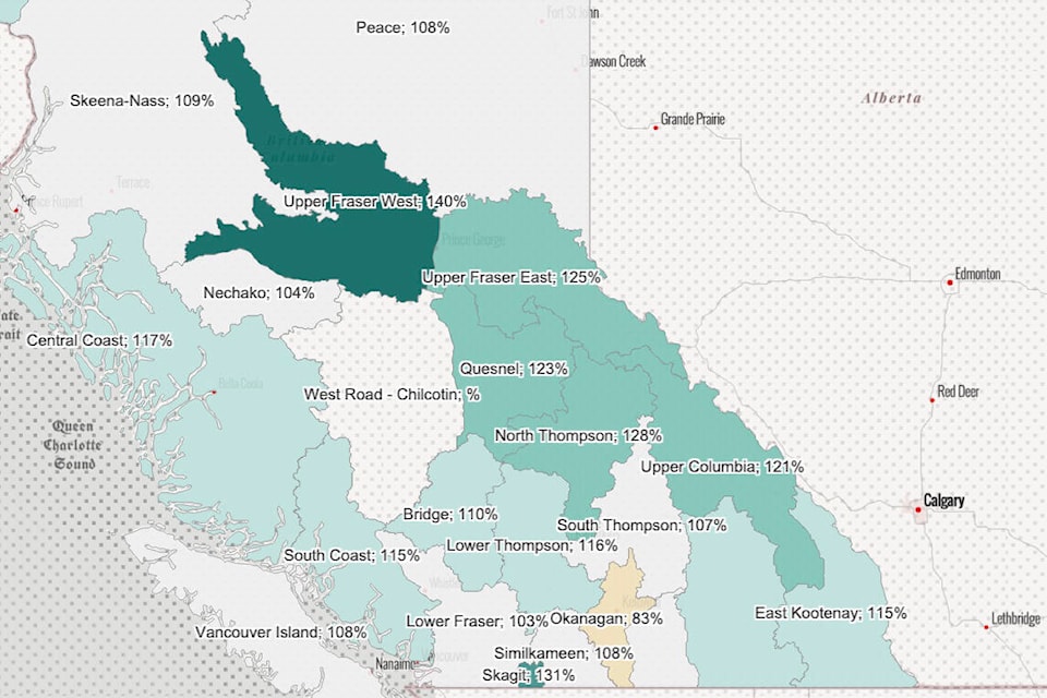
According to the River Forecast centre’s May 1 report, the snow level in the Lower Thompson region was at 116 per cent of normal as of May 1, while the North Thompson was at 128 per cent. Quesnel was at 123 per cent, the Bridge-Middle Fraser region was at 110 per cent, and the South Thompson was at 107 per cent.
The average of all snow measurements for the entire Fraser River basin (upstream of the Lower Mainland and inclusive of Upper Fraser West, Upper Fraser East, Nechako, Middle Fraser, Lower Fraser, North Thompson, and South Thompson) is 114 per cent, increasing from 102 per cent on April 1.
The River Forecast Centre calculates an additional Snow Basin Index for the Fraser River at Hope, based on each basin’s contribution to the total annual flow of the river. The Fraser River at Hope Snow Basin Index is 123 per cent; only five years in the past four decades have had higher May 1 values.
The centre notes that snow pack is only one factor related to the freshet flood risk.
“Weather conditions from May through June determine the timing, magnitude, and rate of snow melt, and heavy rainfall events can exacerbate snowmelt-driven flows,” says the report. “An extreme heat wave, such as the heat dome that occurred in late June 2021, could lead to significant provincial flooding if it occurred between mid-May and mid-June.”
Flooding is also possible in some areas of the province because of the catastrophic floods in November, which caused “significant” erosion and could have changed river channels, including along the Nicola and Coldwater Rivers. These and other rivers could be at increased vulnerability due to flooding at lower levels.
The destruction from the 2021 wildfire season has also affected some streams, rivers, and lakes, making them more susceptible to flooding. Many watersheds sustained significant burn activity, and flows from snowmelt-dominated watersheds that were impacted by fires tend to be greater, and peak earlier, compared to undisturbed areas, even under normal weather conditions.
Areas that recently experienced severe wildfire are at greater risk for higher peak flows. These include Upper and Lower Nicola, Guichon Creek, and the Deadman River, which is currently under a High Streamflow Advisory because of snowmelt and heavy rainfall that occurred in the first week of May.
editorial@accjournal.ca
Like us on Facebook and follow us on Twitter