| Intro | Chapter 1 Heating Up | Chapter 2 New Ground | Chapter 3 Inferno | Chapter 4 Smoke Clears |
|---|
Heart of the Wildfire
Forests, grasslands and lakes comprise the area stretching from Ashcroft to Lac la Hache – an area that found itself at the heart of the 2017 wildfires.
Numerous large fires stretched across the region, with fires to the north near Williams Lake, the Chilcotin and Quesnel, to the east near Clearwater and Little Fort and fires further south in the Okanagan.
The area is vast, and is defined, in part, by three ecosections, as described by the Ministry of Environment.
It is comprised of the Thompson Basin Ecosection, an exceptionally dry, broad and low elevation basin characterized by coloured silt cliffs and deep deposits of sand and gravel. Sagebrush-steppe and bunchgrass-steppe are typical in the area and ponderosa pine and Douglas fir are found in the higher and cooler elevations.
The portions further north make part of the Cariboo Basin Ecosection, a rolling upland area known for its dry forest, interspersed with wetlands and grasslands on south-facing slopes where lakes, streams and wetlands are filled through summer precipitation. Douglas fir forests, lodgepole pine hit hard by pinebeetle and trembling aspen make up a significant section of the forests.
In the east, the Tranquille Upland Ecosystem takes over, where the upper sections of the Deadman and Tranquille streams weave their way through Douglas firs, mountain spruce and Engelmann spruce.
The area, outside of municipal governments, falls under the Cariboo Regional District to the north and the Thompson-Nicola Regional District in the south. The larger municipalities of Ashcroft, Cache Creek, Clinton and 100 Mile House provide economic centres for a dispersed population.
Historical Fire Perimeters
The area is no stranger to fire.
To the southeast 25,420 hectares burned in 2003 during the McLure fire, destroying 72 homes and nine businesses. That fire cost $31.1 million to extinguish and resulted in an additional $8.2 million in property damage – all as the result of a discarded cigarette.
Closer to home, in 2009, more than 130 people were evacuated following a wildfire near 70 Mile House, an area that would find itself evacuated once more over the summer of 2017.
In 2009, five homes and one business burned, but the scars from the wildfire are still visible on the landscape today.
Just to the north, in a research forest just south of 150 Mile House, still part of the Cariboo Basin Ecosection, researchers have found fire used to be much more common in the area.
Looking at tree cores, they have determined that wildfires used to take place, on average, every 15 years until 1943, after which researchers didn’t find any evidence of wildfires.
Part of the lack of fire evidence is due to better fire suppression, especially after the Second World War, says University of British Columbia research supervisor Lori Daniels.
Grazing, which reduces fuel that would have normally carried surface fires, and the removal of Aboriginal cultural fires, which were set as part of traditional land care practices, have also contributed, she says.
“Today’s forest is quite dense and includes trees of a range of sizes that act as ladder fuels. Ladder fuels contribute to wildfires torching and crowning (spreading tree top to tree top) in hot, dry, windy conditions.”
Conditions which, mixed with the environmental context, would serve to provide the ideal setting for an unprecedented wildfire season.
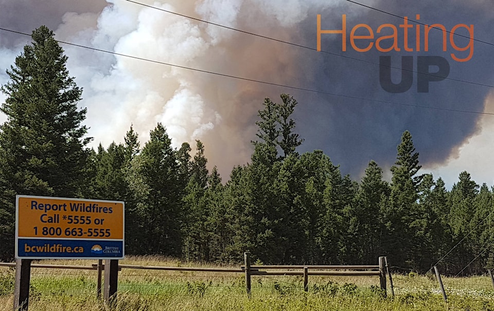
No Rain
On July 6, the interior of B.C. was dry.
| Ed Monical Third generation rancher |
“We hadn’t had any moisture for a considerable length of time. Things were very dry, very tinder, very scary,” says Ed Monical a third-generation rancher who lives just south of 108 Mile House on Tatton Station Road.
“We were reluctant to use our quads for checking fences and putting salt out because it was very dry and even that could start a fire,” he says.
In 100 Mile House, there was 35 mm of precipitation over the summer months of June, July and August: the lowest on record going back to 1970.
There was even less rain in Ashcroft. June saw only 2.2 mm of rain compared to 18.6 mm the year before. While the long-term average is not available for Ashcroft, the community would only get 10 mm of rain in total over the summer months.
On the other hand, temperature-wise June 2017 was not exceptionally hot, with an average of 20 C in 100 Mile House; not far off the previous 10-year average. Meanwhile in Ashcroft, the average daily temperature in June was 27.1 C, above the average of 25.3 C.
The summer as a whole would be warmer than most, but with an average of 24.7 C, it was behind the 2009 summer which was 25.97 C.
“Normally you would get a rainstorm here or there to keep things moist,” says Monical.
“We had some good rain in the springtime. We had lots of growth which is really good for the ranching aspect of things. So then cattle had lots of grass to graze on and stuff like that.
“Then it started getting dry and then we didn’t get our little showers to keep things moist and growing. It just kept getting dryer and dryer.”
It would create the perfect conditions for a record-breaking fire season.
“To understand fire, you need three ingredients,” says Dr. Mike Flannigan, an expert in wildfire and weather interactions, currently working for the University of Alberta.
The first is fuel: grass, shrubs or the types of trees that burn. The second is ignition. Fires are either people or lightning caused.
The third, and most important according to Flannigan, is weather.
“When you get all three, you get fire and people are on the landscape now-a-days. People work and live in the wildlands more than in the past, so you get this intersection between people and fire with devastating results.”
Leading up to July 6, when the fires started, it had been a relatively quiet fire season.
| Kevin Skrepnek Chief fire information officer |
“In terms of the fires we were seeing, they weren’t really unusual for that time of year: flashy, quick moving grass fires, things like that, but in general our statistics were fairly low for where we usually are at that time of year,” says Kevin Skrepnek, chief fire information officer for the BC Wildfire Service.
“It had been a fairly unexciting season up until that point with the exception of a few incidents here and there.”
In the Cariboo Fire Centre, in the past 10 years on average there had been 48 human-caused fires and 27 lightning-caused fires between April 1 and July 4.
This year, there were 48 human-caused fires but only 12 lightning-caused fires, burning a total of 289 hectares up until that point.
In fact, BC Wildfire crews had been put to work on floods in the Okanagan due to an exceptionally wet spring.
| Floodwaters rise behind the firehall in Cache Creek. Barbara Roden photo. |
Floods also hit Cache Creek. Swirling waters swept away the much-beloved fire chief, Clayton Cassidy. Cassidy went missing early in the morning on May 5 while checking water levels around the village. His body was recovered two weeks later.
Still, the wet spring wasn’t enough to prevent the coming fire season.
“Go back to the three ingredients. Really all you need – other than in the wetlands like peat bogs – you just need a week to 10 days of warm, dry, windy weather and you’re ready to burn.”
In fact, the wet spring would only make things worse, says Flannigan.
“In your valleys, where there is grass and sage and things like that, the wet winter means increased grass and vegetation growth. Then, you get a hot, dry summer and it all dies and it burns like stink because there is more of it, it burns more intensely and it is difficult to put out.”
While, over the summer as a whole, there would be less lightning than normal, according to Environment and Climate Change Canada, the Fire Weather Index, produced by Natural Resources Canada as a general index of fire danger, put the area over 30 on July 6 while the mean for July between 1981 and 2010 is between 5 and 20.
Fire weather index on July 6, 2017 and the July average for 1981-2010.
This summer is indicative of a warming trend due to climate change, says Flannigan.
Adding to that, he says the jet stream is getting weaker, which means weather patterns, that typically might move through the region, sometimes stagnate.
“With this climate change and this change in jet streams, you get more longer lasting, or even more intense blocking ridges so it’s hotter and drier. You had a very hot, dry summer in B.C. which dried out all the fuels and the grasses cured, died and became available to burn, so it just played a major role in your fire season.”