A report on the Tremont Creek wildfire, which burned 63,548 hectares east of Ashcroft in July and August 2021, shows that post-fire hazards include the potential for elevated streamflow, flooding, and sediment-laden floods throughout the affected area, which could last for three years or more.
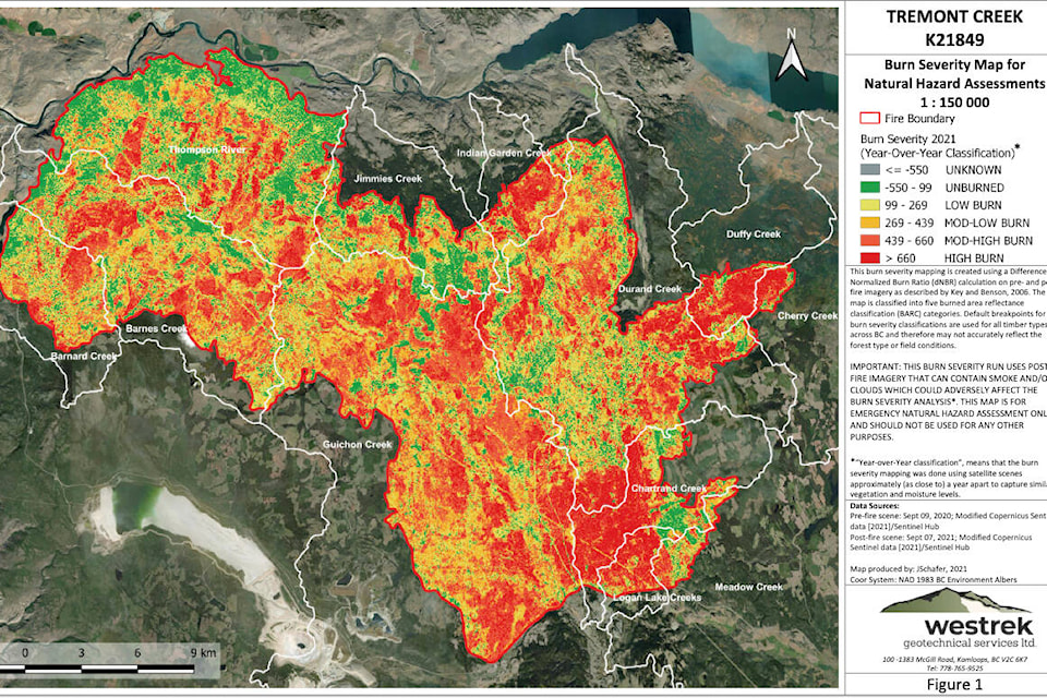
The “Post-wildfire Natural Hazard Risk Assessment Reconnaissance Report” was prepared by Westrek Geotechnical Services Ltd. for the Ministry of Forests, Lands, and Natural Resource Operations and Rural Development. In addition to showing the severity of the fire throughout the impacted area and the watersheds affected, it notes that the likelihood of post-fire flooding ranges from very low (Cherry Creek) to high (Guichon Creek, Chartrand Creek, and Logan Lake).
Approximately 81 per cent of the Barnes Lakes watershed east of Ashcroft — an area of 8,269 hectares — was burned, with 37 per cent of that area subject to moderate or high burn severity.
The report states that there is a moderate likelihood of elevated streamflow and flooding within the Barnes Creek watershed during the spring freshet or after an intense or prolonged rainstorm. The nearby Studhorse Creek watershed could also be subject to a moderate likelihood of elevated streamflow and flooding.
“It is expected that rain and spring snowmelt conditions (i.e., rate of warming, depth of snowpack, soil moisture) that would normally generate streamflow may now produce flashier (i.e., faster time of concentration) and higher magnitude flow,” the report states.
“The severity of the watershed response to the effects of the Fire will be dependent on the coincidence of climate conditions that drive the increased flooding. The effects of the Fire are likely to last for at least three years or until vegetative ground cover on the burned slopes is re-established.”
Flooding in the Barnes Creek watershed will most likely occur in low-lying areas near the YD Ranch and at the north end of Barnes Lake, with the report noting that four buildings on YD Ranch Road and three creek crossings (on the Studhorse, Barnes, and Evans Roads) may experience some issues with flooding. The report advises the Ministry of Transportation to ensure that all culverts on roads at the north end of Barnes Lake are clear of debris and remain functional.
Sediment-laden floods are expected on steeper, open slopes that burned at a moderate/high severity. The loss of a protective tree canopy and soil organic layers (such as forest debris) means that mineral soil is more exposed to precipitation and has a lower capacity to absorb it. This increases flow runoff and soil movement, and generally occurs within the first year after a fire.
Steeper slopes within the watersheds may be vulnerable to these sediment-laden floods. Locations of note singled out in the report in relation to possible sediment-laden floods include Highway 97C within the Barnard Creek watershed on the slopes down into Ashcroft and the CP Rail tracks at small creek crossings on the slopes below the fire between Ashcroft and Walhachin.
Other areas that could be at risk from post-fire hazards include Highway 97D near Logan Lake; Highway 1 near Savona; and Tunkwa Lake and Mount Savona Provincial Parks.
editorial@accjournal.ca
Like us on Facebook and follow us on Twitter