BC Wildfire Service (BCWS) crew continue to battle the Minaberriet Creek wildfire south of Ashcroft, which broke out on the evening of July 28. As of Aug. 2, the fire had grown to 16.7 hectares and was classed as Being Held.
The nearby Cornwall Creek wildfire, which also broke out on July 28, grew to four hectares, but is now classed as Under Control, as is the Cornwall Lookout wildfire to the south on White Mountain. That spot fire was discovered on July 29 when crews arrived to tackle the first two fires.
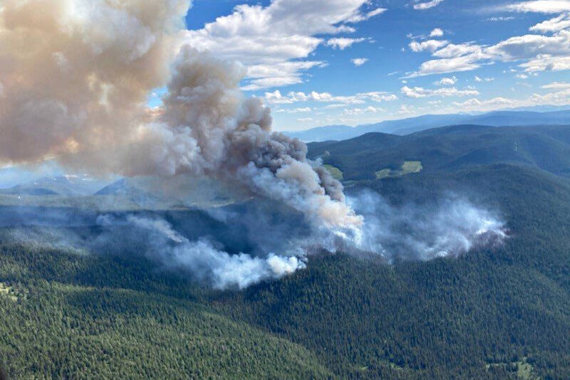
A fourth fire, near Maria Creek FSR north of Marble Canyon Provincial Park on Highway 99, had grown to an estimated 400 hectares as of Aug. 2, and is classed as Out of Control. It was discovered on July 31, and smoke from the fire was clearly visible over Ashcoft and Cache Creek on the evening of Aug. 1.
Lightning storms that rolled through the area between July 28 and 31 are thought to be the cause of all four fires.
Ashcroft Fire Rescue was called out to the initial two fires south of Ashcroft on July 28, along with BC Wildfire Service. All three fires are in close proximity to each other near Hat Creek Road on the west side of Highway 1 south of Ashcroft.
On July 29, a tanker was dropping retardant on the fires, and a helicopter was dropping water. Fire Information Officer Melanie Bibeau said on Aug. 1 that one unit crew of approximately 20 people was on the ground, along with two unit crews of five people each. She added that these resources are being shared between the three fires in the area.
The Maria Creek fire is burning in a densely forested area, and Fire Information Officer Karley Desrosiers says that the biggest challenge for fire crews has been lack of road access to the area.
“Heavy equipment has been establishing access and building a guard around the eastern and southern portions of the fire.” She adds that heavy winds, high temperatures, low humidity, and a dense fuel source drove the fire’s growth on Aug. 1.
“The growth has been in the northeastern area and has now reached some cutblocks, so we’re not expecting substantial growth. It’s likely that smoke will continue to be visible from Ashcroft, Cache Creek, Clinton, and the surrounding area, but there is no threat to communities or the highway.”
Two unit crews of 20 people each and an initial attack crew are actioning the fire on the ground. Eleven helicopters are being shared between the Maria Creek and Nohomin Creek fires, and air tanker support is available.
After a cool, damp spring, a prolonged hot spell has seen daytime temperatures in the region exceed 40° C. for several days, and has left the ground and vegetation tinder dry. The daytime high in the area was expected to dip as low as 21° C. on Aug. 4, with a 90 per cent chance of rain, then increase to the mid-30s through Aug. 10 with no precipitation in the forecast.
You can check on the status of all active wildfires in the province on the BC Wildfire Service interactive map at https://bit.ly/3uXd2kr. Check highway conditions and road closures by going to www.drivebc.ca.
editorial@accjournal.ca
Like us on Facebook and follow us on Twitter