The most cursory look at the landscape of this region shows the scars of violent events of the past; geologic upheavals that gouged out riverbeds and valleys, sculpted the hillsides, and created vistas that are, in the words of writer Bruce Hutchison, “for the strong eye only”. Many of these events happened well before humans arrived here, leaving only clues to be deciphered by those trained to read them, although their effect is clearly visible all around us.
A section of the landscape just to the south of Ashcroft has, we know, been marked by landslides over tens of thousands of years; the evidence is plain. But one of the most cataclysmic of those landslides occurred just as settlers were coming to the area and taking note of what was happening here, and thus we have a record—sketchy as it is—of one of those upheavals.
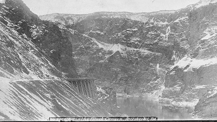
Readers will recall my account of the Peerless, the paddlewheeler which in June 1881 was sent via the Thompson from Savona to Spences Bridge and back again in an attempt to see if the river was a suitable navigation route for supply vessels. The trip down was uneventful; but on the return trip the Peerless took five days to get through an area south of Ashcroft called Black Canyon, a narrow stretch of river bordered by steep cliffs that channeled the river’s flow into an unrelenting barricade. It was only through the skill of the captain that the Peerless was not destroyed.
Perhaps the gallant Peerless would have had less trouble had she tried to make it through Black Canyon a little less than a year earlier. For on October 14, 1880 a massive landslide, now known as the great slide, occurred to the east side of the river, just north of Black Canyon, completely blocking the river and dumping innumerable tons of debris into the Thompson.
By coincidence, Bishop Acton Windeyer Sillitoe of the diocese of New Westminster was traveling through the area with his wife at the time. They had stopped for a few days at what they called “Ashcroft”, but which we now know as Ashcroft Manor, as guests of the Cornwall brothers. In 1880, what is now Ashcroft consisted of Harper’s mill, which had been brought down from Clinton in 1879 and reassembled somewhat north of the future town at the confluence of the Bonaparte and Thompson rivers. The future town site itself was ranchland being worked by men such as John Barnes and William Brink.
In A Memoir of Acton Windeyer Sillitoe (1899), author Herbert Gowen talks of the bishop and his wife having arrived at Ashcroft (“a very English settlement, for two of the farmers [the Cornwall brothers] were found keeping a pack of foxhounds with which to hunt the coyotes”). Mrs. Sillitoe later recalled that:
“Whilst we were sitting in the drawing-room one evening during our stay in Ashcroft, an extraordinary noise was heard. Some supposed it to be an earthquake, but we finally came to the conclusion that it was nothing more than the moving of some chairs or tables overhead. The next morning, however, we heard that the sound had been caused by a tremendous landslip three miles distant from where we were, and which had dammed up the river until it should have forced its way through this immense dam.”
The Bishop and his wife were not alone in traveling to the site, and what they saw was nothing short of incredible: “We found that the dam was half-a-mile long and 80 feet high. The river above [to the north] had already risen 40 feet over its usual level, and was almost dry below.”
The Colonist newspaper reported that the obstruction was as high as 120 feet in places. The river eventually rose to sixty feet on the north side of the dam, and the site where Ashcroft is now located was more than a foot-and-a-half deep in water. Despite being a substantial structure, Harper’s mill, on the edge of the Thompson River, was under real threat of being washed away unless something was done to allow the dammed-up water to escape.
There was also a fear of what would happen if the blockage suddenly gave way under the pressure of the water built up behind it. A powerful rush of water through the breach at the head of Black Canyon—a deep and narrow gorge carved out of bedrock—would have caused massive damage as far downstream as Spences Bridge, 20 miles south.
R.T. Ward, who was in charge of Harper’s mill, mustered a crew of men to the site of the slide, and after hours of back-breaking labour they managed to dig a channel through the top of the slide. The natural force of the pent-up water did most of the rest of the work, washing away loose gravel and soil. Within forty-eight hours of the slide, the river was down to its usual level and the water was running normally again.
In the end, the only material damage of the great slide was that two farmsteads were covered in water, and J.C. Barnes lost his home and several outbuildings. The Harper’s mill building had been half-submerged for more than 24 hours, and it took some time for it to be cleaned and for it to dry out. A wooden sign was placed at the site to commemorate the event, reading “Big Slide, 1880, high water mark”. Although the mill itself is long gone, the sign remains, now proudly displayed in the Ashcroft museum.
The site of the great slide can be seen clearly from the west side of the Thompson River. Both the Canadian National (CN) and Canadian Pacific (CP) lines run through the narrow confines of Black Canyon, with the CN carving its way through a 1,366 ft. tunnel in the canyon’s west side, and the CP line running along the toe of the Great Slide site. It’s an ideal place for trainspotting, and for reflecting on the forces which shaped our area.