The latest “Snow Survey and Water Supply Bulletin” from the BC River Forecast Centre shows that the province’s snow pack is below normal for Feb. 1, with the average of all snow measurements across B.C. at 79 per cent of normal (21 per cent below normal).
The continued below normal snow pack is an early indicator that some regions in B.C. might have drought concerns this spring and summer. The overall snow basin index for the entire Fraser River basin (e.g., upstream of the Lower Mainland) on Feb. 1 is 75 per cent, significantly lower than last year’s 108 per cent on the same date.
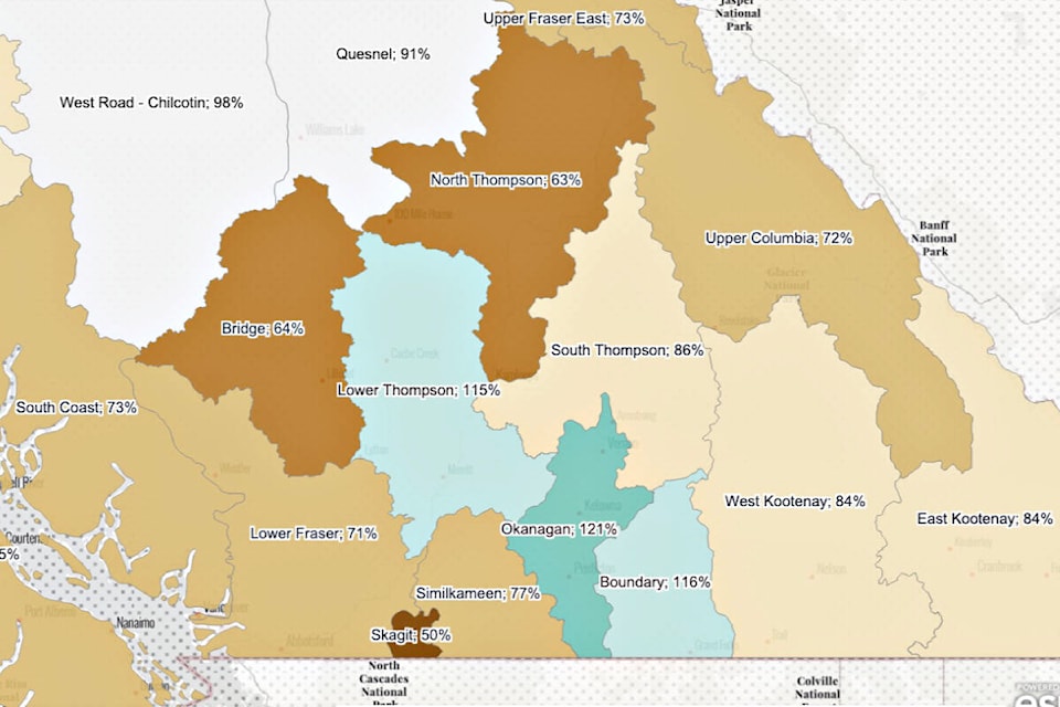
Only three areas had above average snow measurements, with Lower Thompson (which includes Lytton, Ashcroft, Cache Creek, Clinton, and Merritt) at 115 per cent of average (down from 200 per cent of average in January). The other two areas that continue to show above average snow accumulations as of Feb. 1 are Okanagan (115 per cent of normal, down from 135 per cent on Jan. 1) and Boundary (116 per cent, down from 129 per cent on Jan. 14).
At the other extreme, the Bridge area (which includes Lillooet) is at 69 per cent of normal, while the North Thompson area is at 63 per cent, which is near a historic low for the region. The snow station at Adams River in the North Thompson recorded an all-time record low measurement on Feb. 1 (records for the station go back 41 years).
Temperatures across B.C. were warmer than normal for January, with most regions of the province ranging from +1.0 to +4.0 C above normal for the month. The northerly sections of B.C., including Fort St. John, Fort Nelson, and Dease Lake, were +4.0 to +7.0 C above normal.
Generally, January was also drier than normal, although areas in the Cariboo — including Quesnel and Williams Lake — recorded slightly above normal precipitation.
Significant drought conditions in summer and fall 2022 were accompanied by a September and October that were much warmer than usual. On Thanksgiving Day 2022 (Oct. 10), Ashcroft recorded a high of 28.2 C, almost four degrees higher than the old record for that day of 24.4 C set in 1945.
These conditions were followed by extended cold and dry weather in November and December, which limited snow accumulation in the mountains. December was cold throughout the province, with temperatures -8 C to -1 C below normal.
On average, by Feb. 1 nearly two-thirds of the seasonal B.C. snow pack has typically accumulated. The report notes that with two or more months left for snow accumulation, the seasonal snow pack levels can still change based on weather patterns.
The Climate Prediction Center indicates there will be a transition from La Niña conditions through the remainder of winter (February through April). Historically, when winter La Niña conditions exist in B.C., the April 1 snow pack is often above normal, particularly for the South Coast and Southern Interior.
However, La Niña conditions that persist into the spring can lead to late-season snow accumulation and delayed snowmelt, which increases the risk of freshet flooding. Currently, the regions in the South Interior with slightly above normal snow pack, such as Lower Thompson, have the greatest risk for snowmelt-related flooding in the spring.
The River Forecast Centre will publish its next Snow Survey and Water Supply Bulletin on March 8.
editorial@accjournal.ca
Like us on Facebook and follow us on Twitter