The latest “Snow Survey and Water Supply Bulletin” from the BC River Forecast Centre shows that the province’s snow pack increased significantly to near normal for March 1, with the average of all snow measurements across B.C. at 94 per cent of normal. This contrasts sharply with the Feb. 1 report, which showed an average of all snow measurements across the province at only 79 per cent of normal.
The Fraser River at Hope snow index is near normal, at 101 per cent. The overall snow basin index for the entire Fraser River basin (e.g., upstream of the Lower Mainland) on March 1 is 94 per cent, a significant increase over Feb. 1’s 75 per cent. At this time last year, the snow pack for the entire Fraser River basin upstream of the Lower Mainland was at 108 per cent.
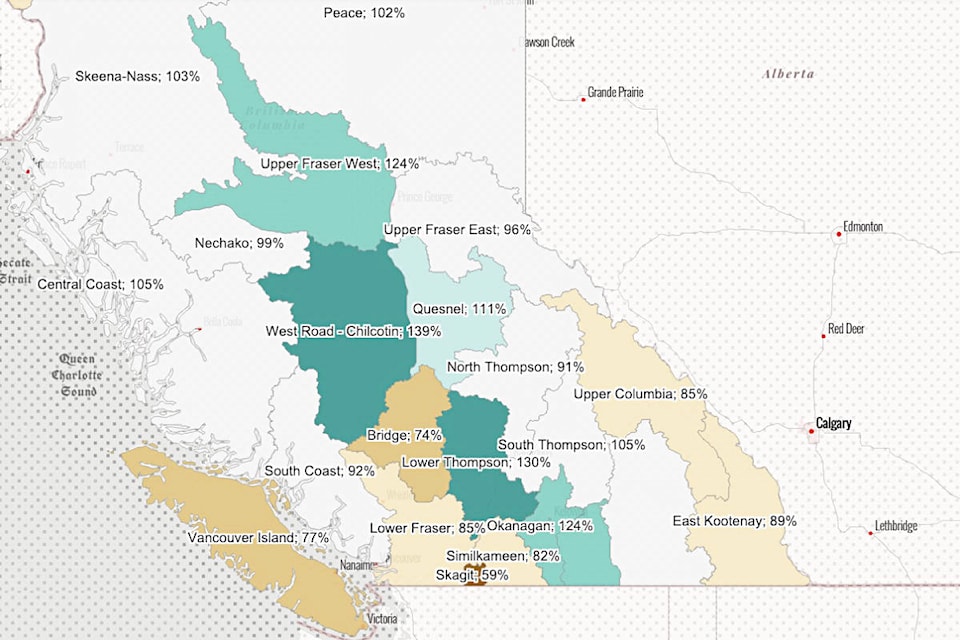
As of Feb. 1, only three areas in the province had above average snow pack. As of March 1 that number had increased to 13, with Lower Thompson — which includes Lytton, Ashcroft, Cache Creek, Clinton, and Merritt — at 130 per cent of normal, up from 115 per cent in February. The area was second only to Chilcotin (139 per cent of normal); other areas with above normal snow pack include Okanagan (124 per cent), Boundary and Nicola (each 123 per cent), Quesnel (111 per cent), and South Thompson (105 per cent).
At the other extreme, the Bridge area (which includes Lillooet) is at 74 per cent of normal, the second-lowest average in the province.
Above normal snow indicates a higher risk for snowmelt-related spring flooding for the Upper Fraser West, Chilcotin, Okanagan, Lower Thompson, and Boundary basins. Basins with near normal or slightly below normal snow pack are still at risk for spring flooding if adverse weather occurs.
Temperatures across B.C. were near normal for February, and the month was drier than normal for Vancouver Island, the South Coast, and regions in the Southern Interior. Areas with above normal precipitation included Skeena/Bulkley and Cariboo; the Quesnel Airport weather station measured the third wettest February since 1893. Prince Rupert was the fourth wettest February since 1909, Terrace was the fifth wettest since 1913, and Kamloops was the seventh wettest since 1891.
The above normal precipitation had a significant impact in mountain snow accumulation during the month. Seasonal precipitation occurred during the first week of March, resulting in modest snow accumulation so far.
On average, by March 1 nearly 80 per cent of the seasonal B.C. snow pack has typically accumulated. The report notes that with two more months of potential snow accumulation left in the season, snow pack levels can still change significantly based on weather patterns.
La Niña conditions existed throughout the fall and winter of 2022-23. Typically, La Niña years lead to increased late season snowfalls and a delayed onset of snowmelt. This was the third La Niña in a row, with it present during fall-winter of 2020-21 and 2021-22. La Niña occurs when oceanic temperature anomalies along the equatorial Pacific region are below normal for an extended period.
Historically, when winter La Niña conditions exist in B.C., the April 1 snow pack is often above normal, particularly for the South Coast and Southern Interior. When those conditions persist into the spring they can lead to late-season snow accumulation and delayed snowmelt, which increases the risk of freshet flooding.
Seasonal weather forecasts from late February indicate a greater likelihood of below normal temperatures from March through May for all of B.C.
Flooding is a provincial risk every spring due to a combination of snowmelt and/or rainfall (also known as freshet). Rivers are at risk for flooding, even if the snow pack is below normal. The weather conditions during spring play a critical role in the rate at which the snow melts. A gradual warming under dry conditions is ideal to lessen the flood risk. A lengthy cold period with high amounts of precipitation, followed by a sudden extreme heat wave, could lead to catastrophic conditions, especially if additional rain follows.
The unprecedented and catastrophic flooding that occurred in November 2021 has made many rivers more vulnerable to flooding. Due to the significant erosion and possible changes in river channel morphology that occurred within many areas, rivers may be at increased vulnerability to high flows at lower levels than previous freshet seasons.
Currently, the Nicola River has a higher risk, as it measures above normal snow pack for March 1.
The most likely cause for major flooding would be a period of persistent cool temperatures and wet weather into the late spring, followed by a sudden heat wave of at least five or more days. There is evidence that the 1948 and 1894 floods on the Fraser River were caused by this scenario. The 1894 flood destroyed the bridges at Savona, Ashcroft, and Spences Bridge, as well as the first Alexandra Bridge near Spuzzum.
The River Forecast Centre will publish its next Snow Survey and Water Supply Bulletin on April 12.
editorial@accjournal.ca
Like us on Facebook and follow us on Twitter